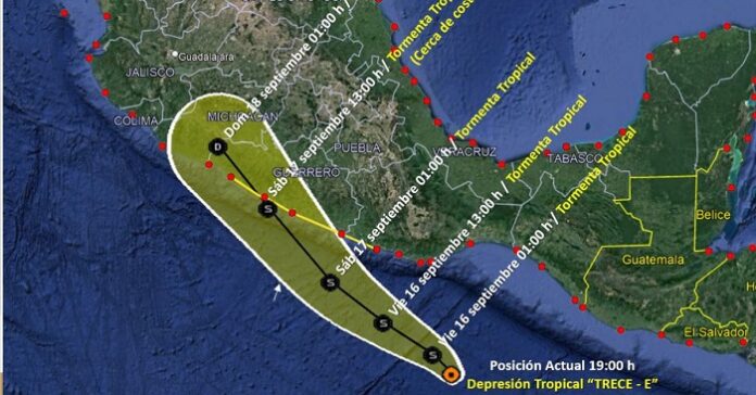
Tropical Storm Lester is tracking northwest over the North Pacific Ocean off far western Oaxaca State early Sept. 17. As of 04:00 CDT, the system’s center of circulation was approximately 215 km (135 miles) southeast of Acapulco, Guerrero State.
Forecast models indicate that the storm will continue tracking northwestward and make landfall as a tropical storm over south-central Guerrero State the afternoon of Sept. 17. After landfall, the storm is likely to weaken rapidly and dissipate over the far southeastern Jalisco State early Sept. 18. Some uncertainty remains in the track and intensity forecast, and significant changes could occur over the coming hours.
As of early Sept. 17, authorities have issued a tropical storm warning for Puerto Escondido to Zihuatanejo and a tropical storm watch for west of Zihuatanejo to Lazaro Cardenas. Authorities will likely issue new warnings or update existing advisories throughout the system’s progression in the coming days. Forecast models indicate 7.5-15 cm (3-6 inches) of rainfall across coastal portions of western Oaxaca, Guerrero, Michoacan, Colima, and Jalisco states through Sept. 18; flash and urban flooding, as well as mudslides in areas of higher terrain near the coast, are possible. Swells are likely to affect portions of southern Mexico’s coast through Sept. 18; life-threatening surf and rip current conditions are likely.
Early reports indicate flooding in some areas of Guerrero State due to rivers and stream overflowing. Chilpancingo and Tixtla towns are the worst affected, with more than 30 houses flooded. Authorities in the state have closed ports due to high waves and set up around 600 emergency shelters in vulnerable areas in preparation for evacuations.
Sustained heavy rainfall could trigger flooding in low-lying areas and those with easily overwhelmed drainage systems. Localized evacuations, flash flooding, and landslides are possible if weather conditions prove hazardous. The inclement weather could trigger localized business, transport, and utility disruptions, rendering some bridges or roadways impassable. Flight disruptions at regional airports and temporary closures of ports are also possible. Stagnant pools of water during and after flooding increase insect- and waterborne diseases, such as dengue fever, cholera, and malaria. Raw sewage and other hazardous materials mixed with floodwaters pose a serious health threat.
Source: El Universal


